 NEUON AI SDN BHD
Smart Mobility Division
NEUON AI SDN BHD
Smart Mobility Division
Smart Mobility
Integrated Traffic Intelligence Suite
- 01 Traffic Watch
- 02 Traffic Vector
- 03 Greenlight
- 04 D'Reporter
The problem
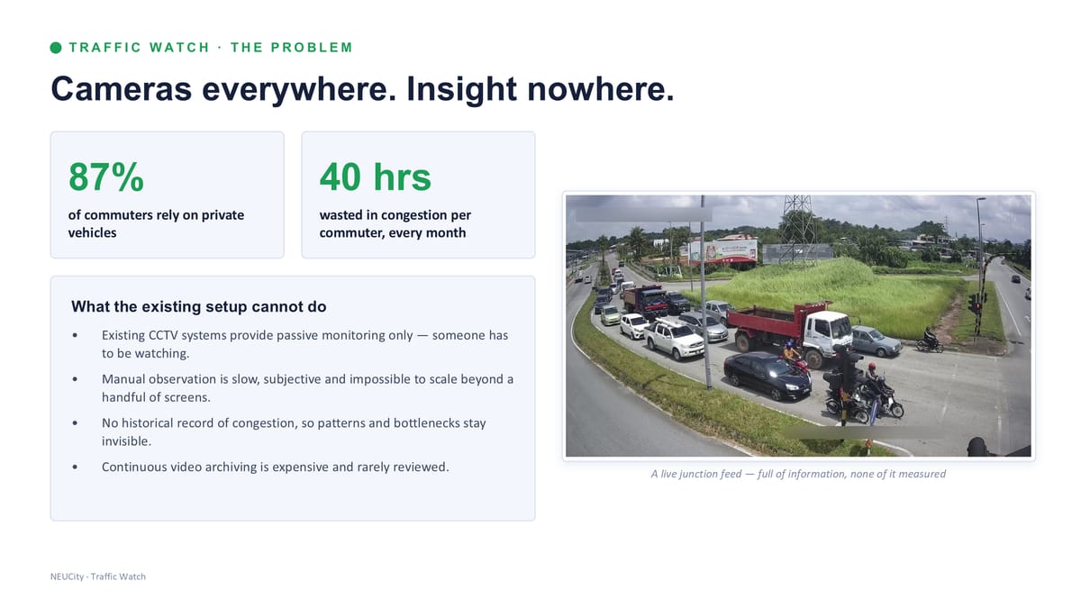
Cameras everywhere. Insight nowhere.
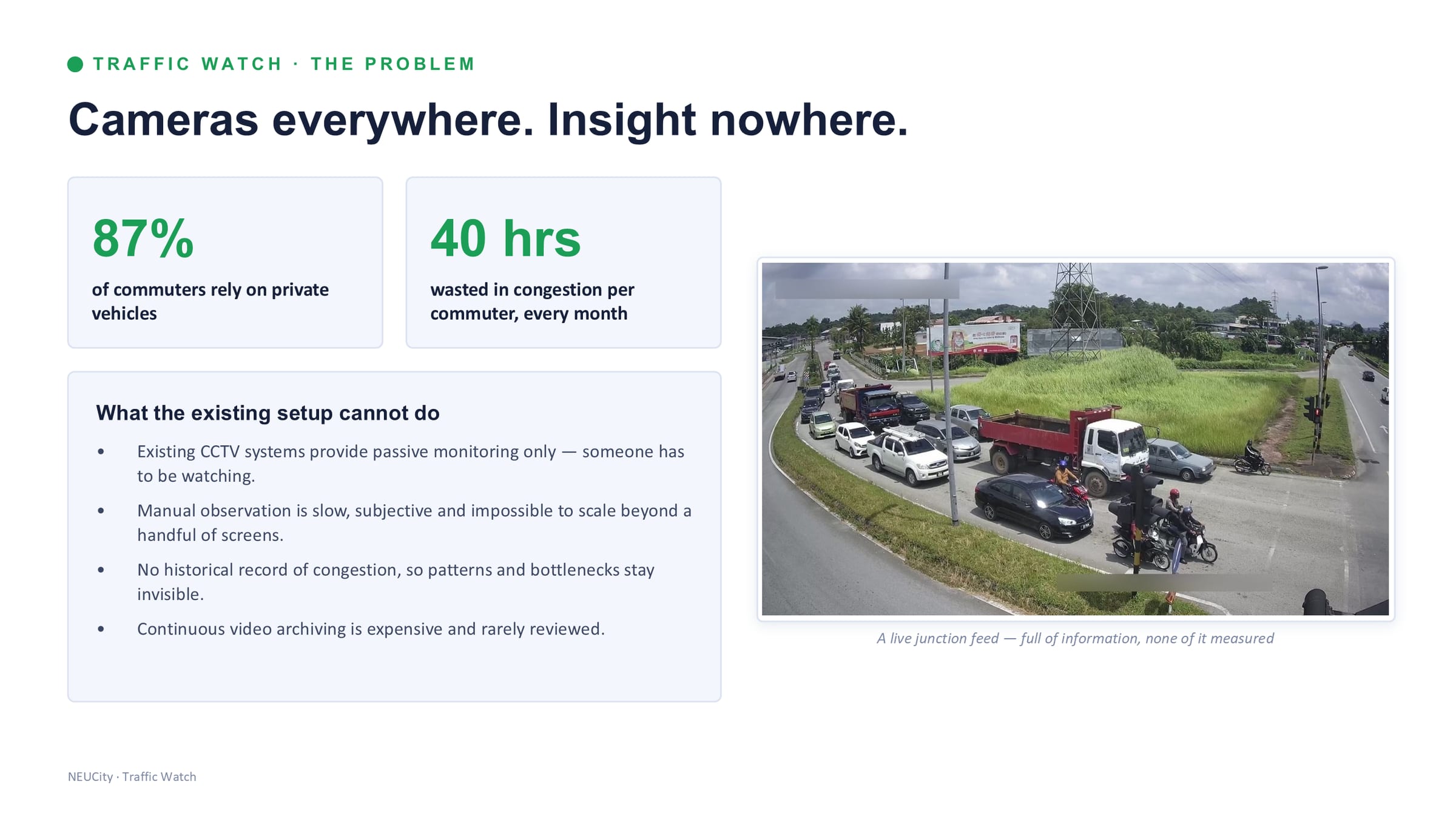
What the existing setup cannot do
- Existing CCTV systems provide passive monitoring only — somebody has to be watching.
- Manual observation is slow, subjective and impossible to scale beyond a handful of screens.
- No historical record of congestion, so patterns and bottlenecks stay invisible.
- Continuous video archiving is expensive and rarely reviewed.
Source 1
Where this came from
- Dr KC's NEUCity deck — “Integrated Traffic Intelligence Suite, Product & Service Catalogue, Version 1.0”, NEUON AI Smart Mobility Division, 34 slides, slide 05 — the problem — cameras everywhere, insight nowhere /assets/img/mobility/slide-05.jpg
The infrastructure to understand Sarawak's traffic is mostly installed already. It is simply passive. NEUCity's Smart Mobility suite makes it active — four services bringing cameras, signals and junctions under a single AI layer, each answering a different question, and they stack.
The suite
Four services. One traffic intelligence platform.
Each service answers a different question, and they stack: observe, measure, control, enforce. Press a card to read it.
Observe
Traffic Watch — observe
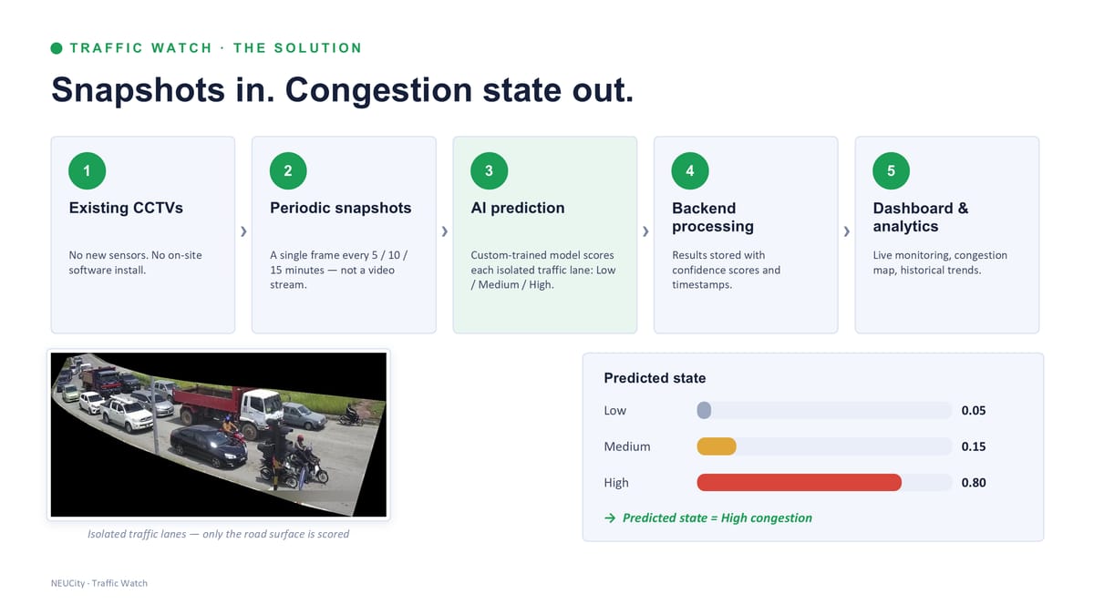
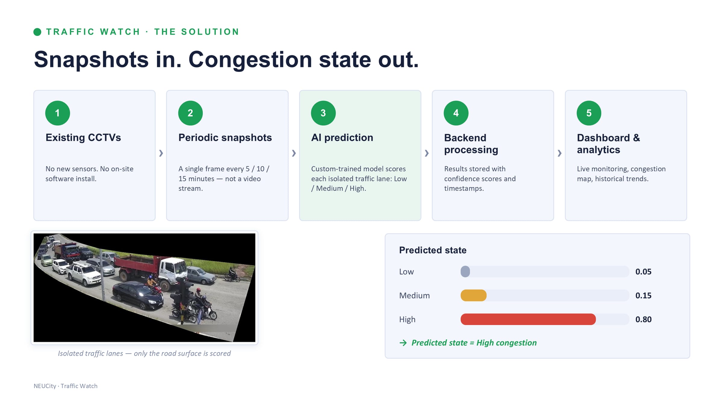
Snapshots in. Congestion state out. No new hardware on the roadside.
Existing CCTV → snapshots → congestion state per lane, refreshed every 5 minutes.→ Live map, heatmaps, alerts
In words
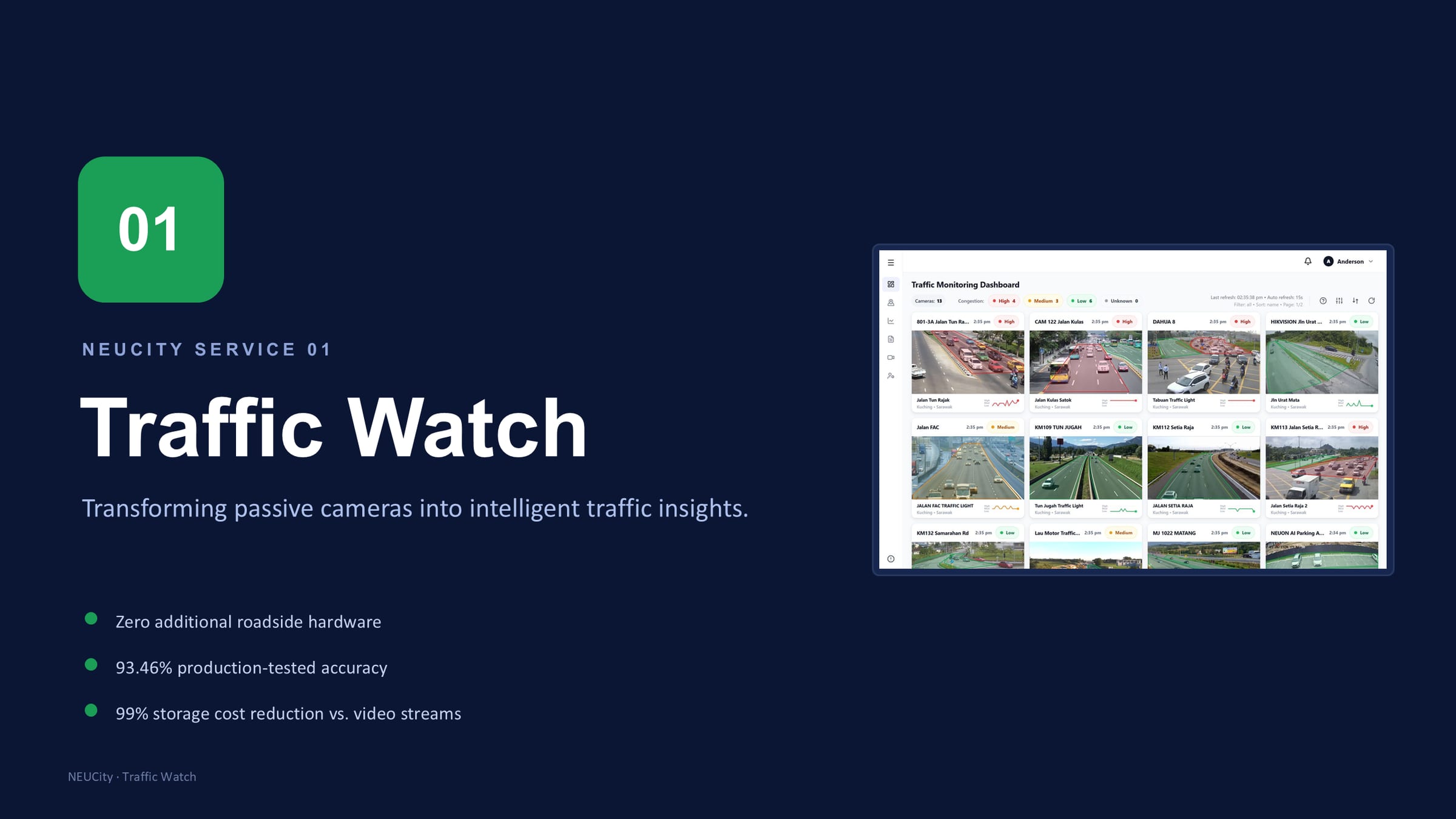
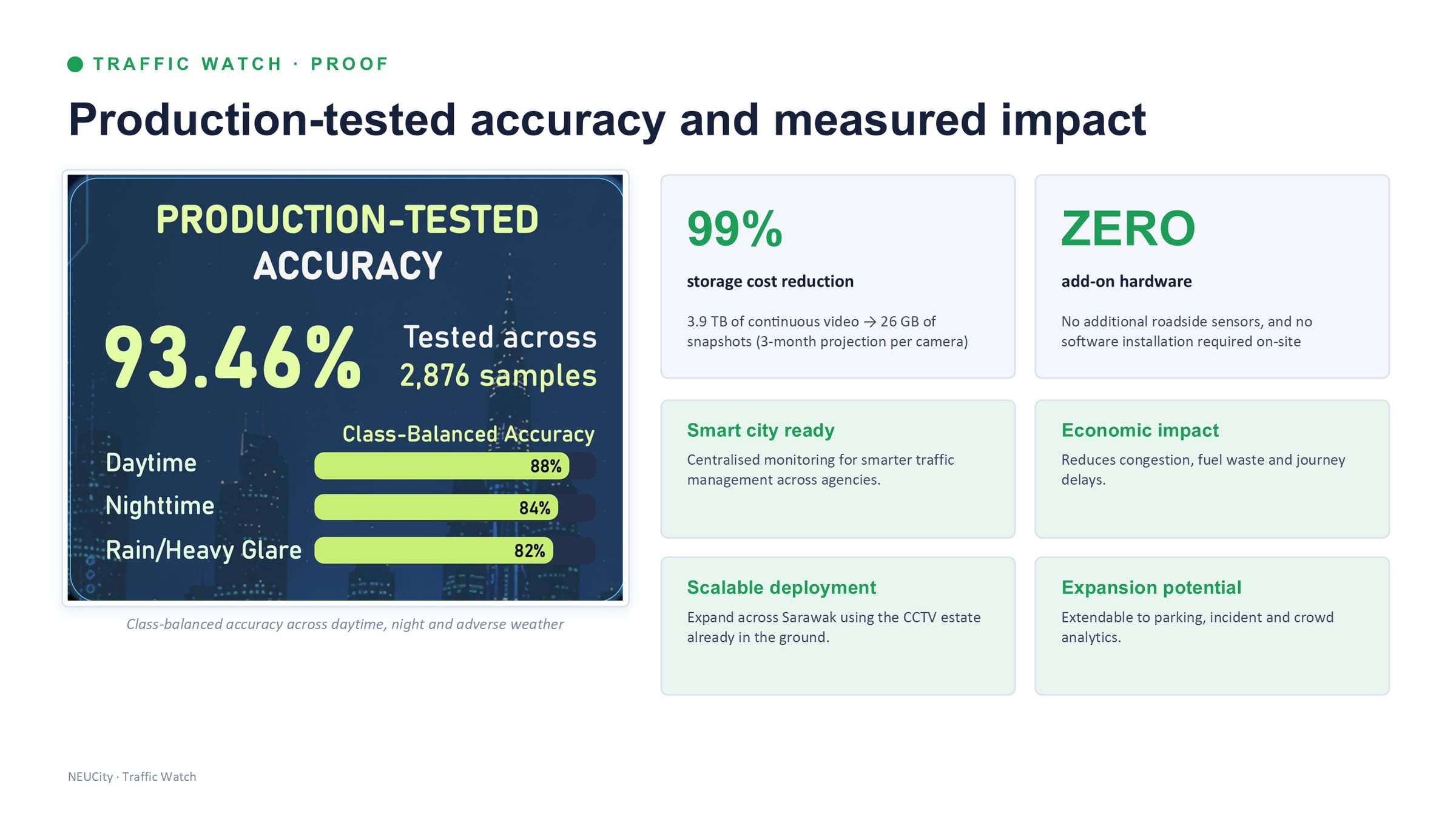
Traffic Watch does not stream video. It takes a single frame every 5, 10 or 15 minutes from cameras that are already installed, scores the road surface in each isolated traffic lane as Low, Medium or High congestion with a custom-trained model, and stores the result with its confidence score and a timestamp. A dashboard and a congestion map are built out of those readings.
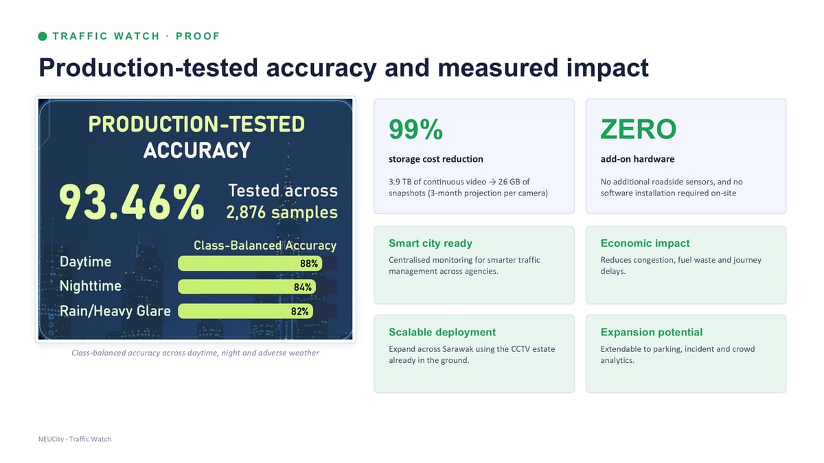
Working from still frames rather than continuous video is the whole design, and it is what makes the economics work: three months of continuous video from one camera is about 3.9 TB, and the same period of snapshots is about 26 GB — a 99% reduction. There are no additional roadside sensors and no software to install on site.
Accuracy is 93.46%, measured on 2,876 production samples and reported class-balanced rather than as a single flattering average: 88% in daytime, 84% at night, and 82% in rain or heavy glare. The night and bad-weather figures are the ones that matter, because that is where imported off-the-shelf detection usually stops working.
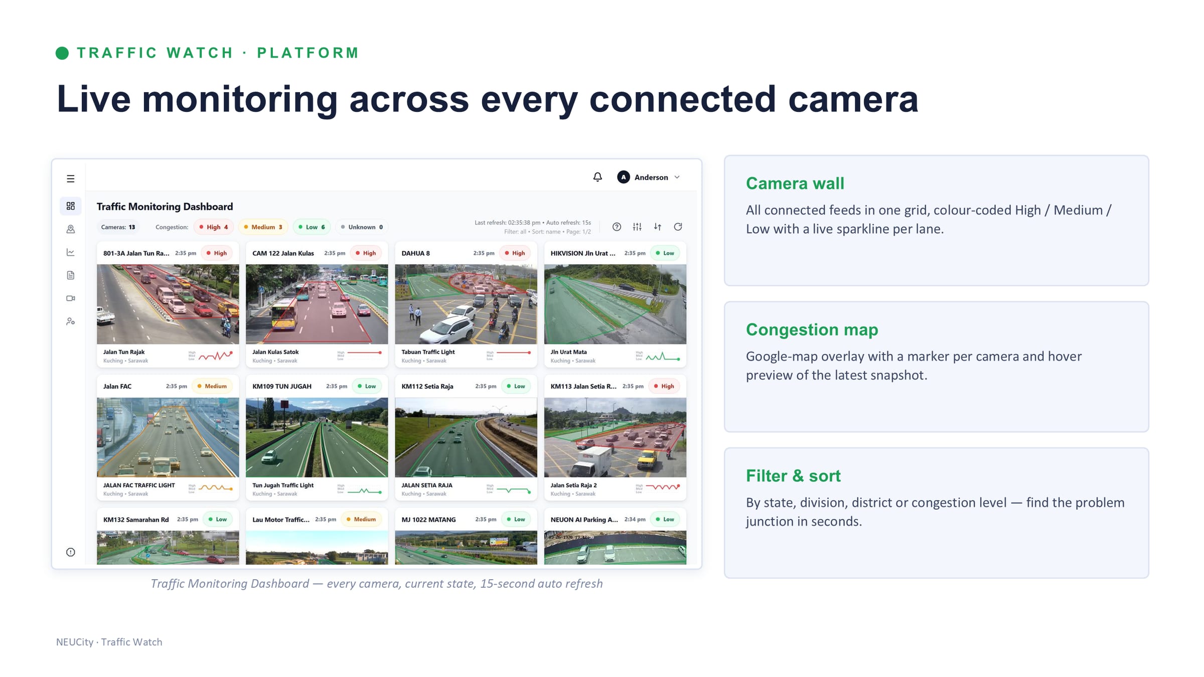
- Camera wall. Every connected feed in one grid, colour-coded High / Medium / Low, with a live sparkline per lane.
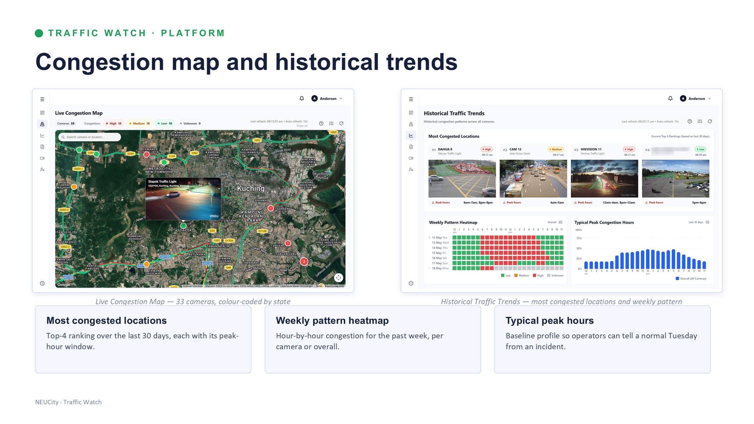
- Congestion map. A map overlay with a marker per camera and a preview of the latest snapshot.
- Filter and sort by state, division, district or congestion level — find the problem junction in seconds.
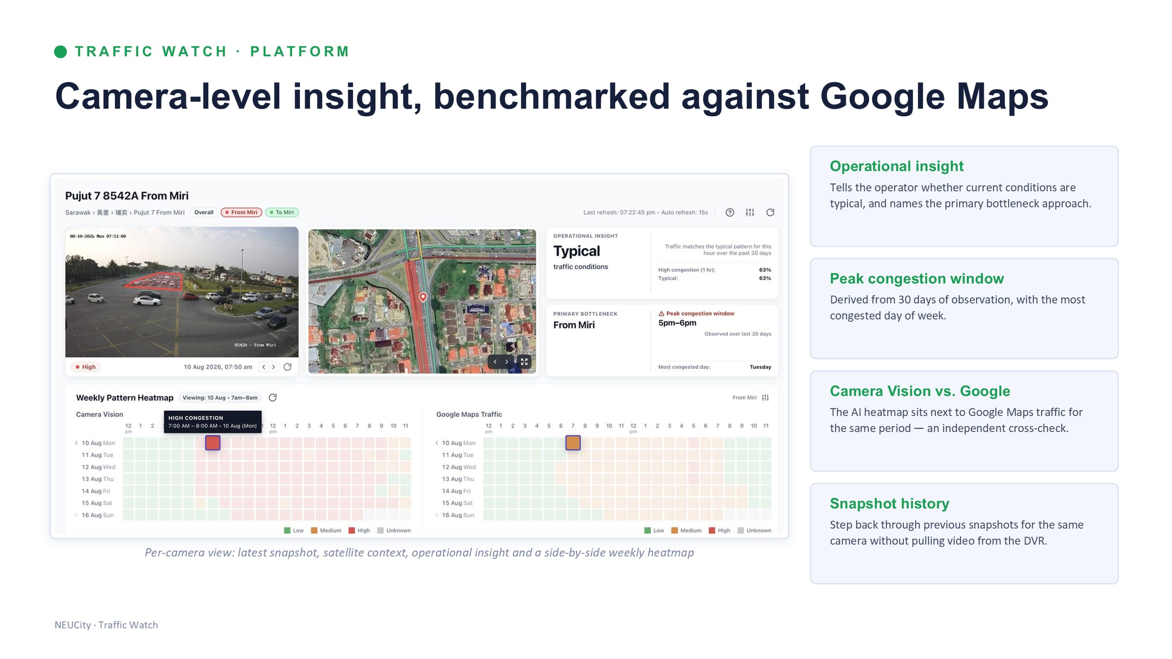
- Per-camera insight. Latest snapshot with satellite context, whether current conditions are typical for this hour, the primary bottleneck approach, and the peak congestion window derived from 30 days of observation.
- An independent cross-check. The AI heatmap is shown beside public mapping traffic data for the same period, so the platform can be audited against something outside it.
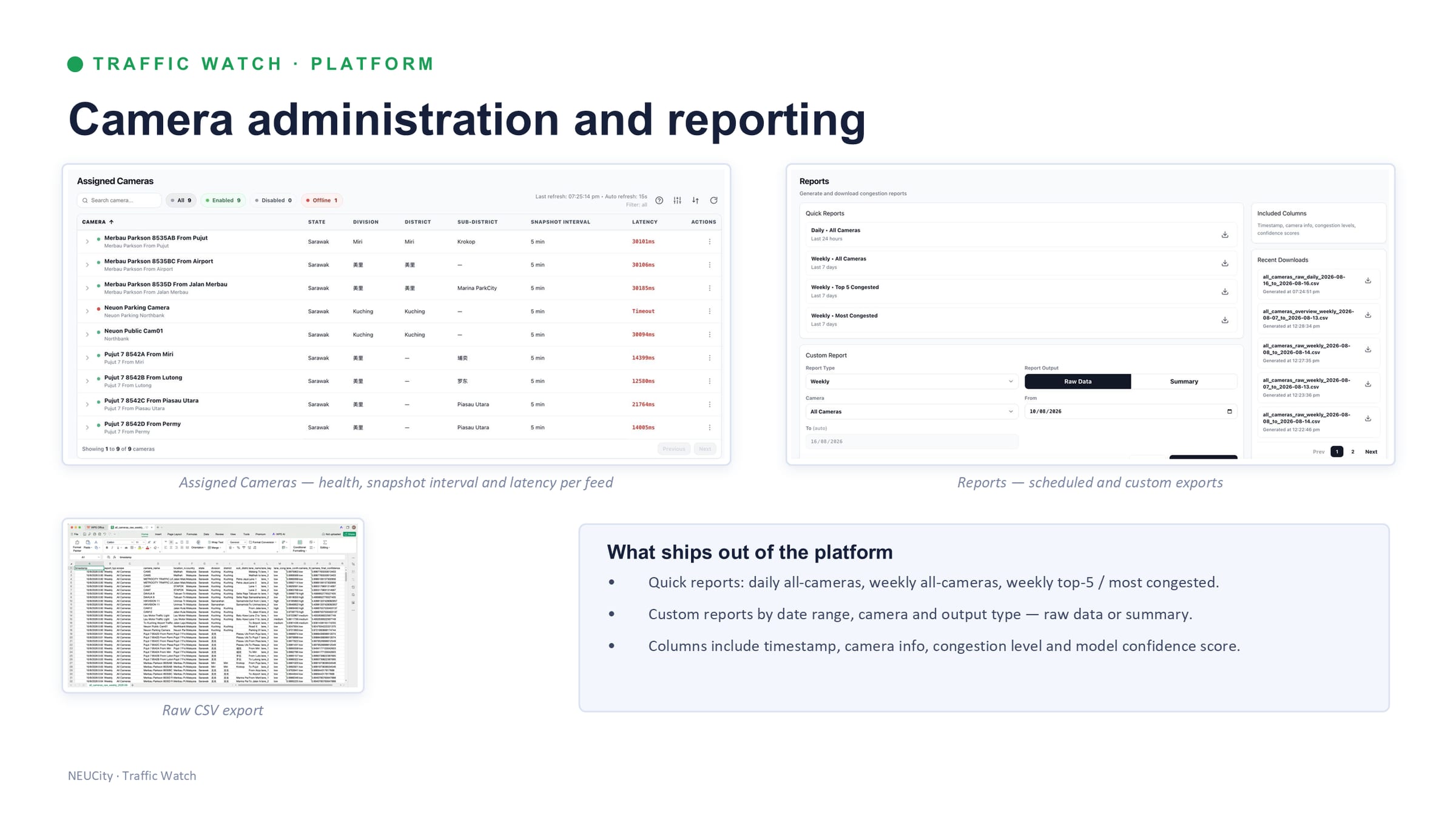
- Reporting. Daily and weekly all-camera reports, weekly top-5 and most-congested, plus custom reports by date range and camera — raw CSV or summary, with timestamp, camera, congestion level and model confidence in the columns.
- Camera health. Snapshot interval, latency and uptime per feed, so a dead camera is visible as a dead camera rather than as an absence of congestion.
Sources 2
Where this came from
- Dr KC's NEUCity deck — “Integrated Traffic Intelligence Suite, Product & Service Catalogue, Version 1.0”, NEUON AI Smart Mobility Division, 34 slides, slide 11 — proof — production-tested accuracy and measured impact /assets/img/mobility/slide-11.jpg
- 93.46% is measured across 2,876 production samples and reported class-balanced: 88% day, 84% night, 82% rain or glare. The sample set itself is not published.
Source 1
Where this came from
- Dr KC's NEUCity deck — “Integrated Traffic Intelligence Suite, Product & Service Catalogue, Version 1.0”, NEUON AI Smart Mobility Division, 34 slides, slide 06 — the solution — snapshots in, congestion state out /assets/img/mobility/slide-06.jpg
Measure
Traffic Vector — measure
A turning-movement study from recorded footage, without enumerators at the roadside.
Recorded footage → detection, tracking, classification → turning-movement counts.→ Excel / CSV traffic study
In words
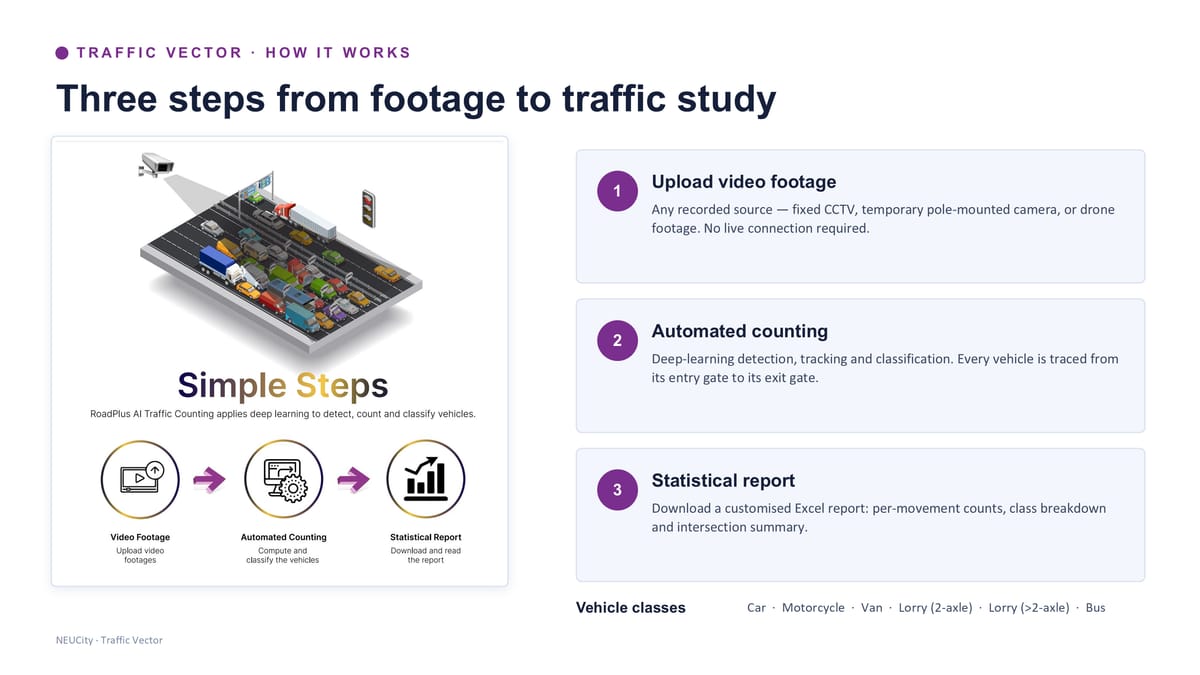
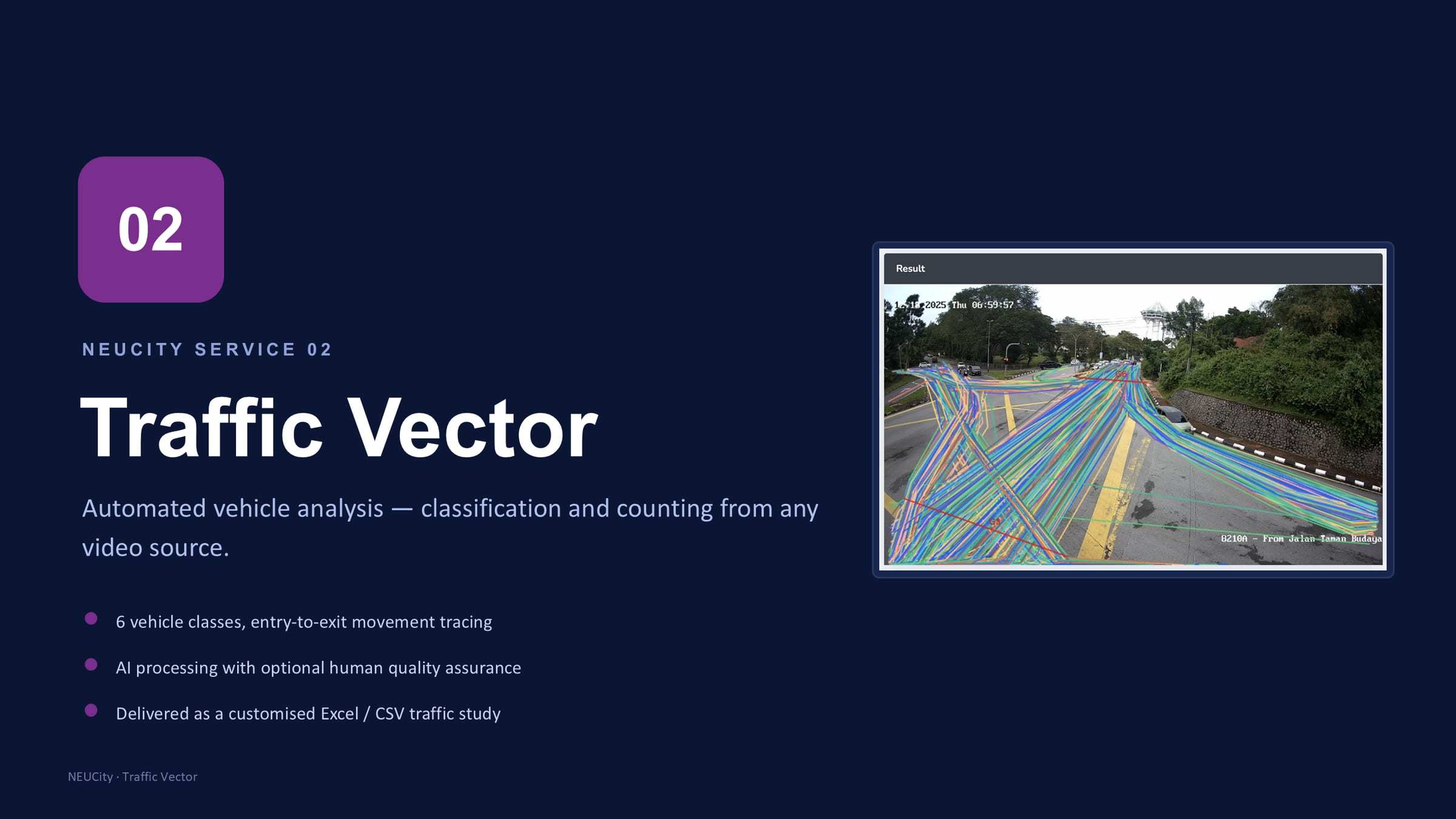
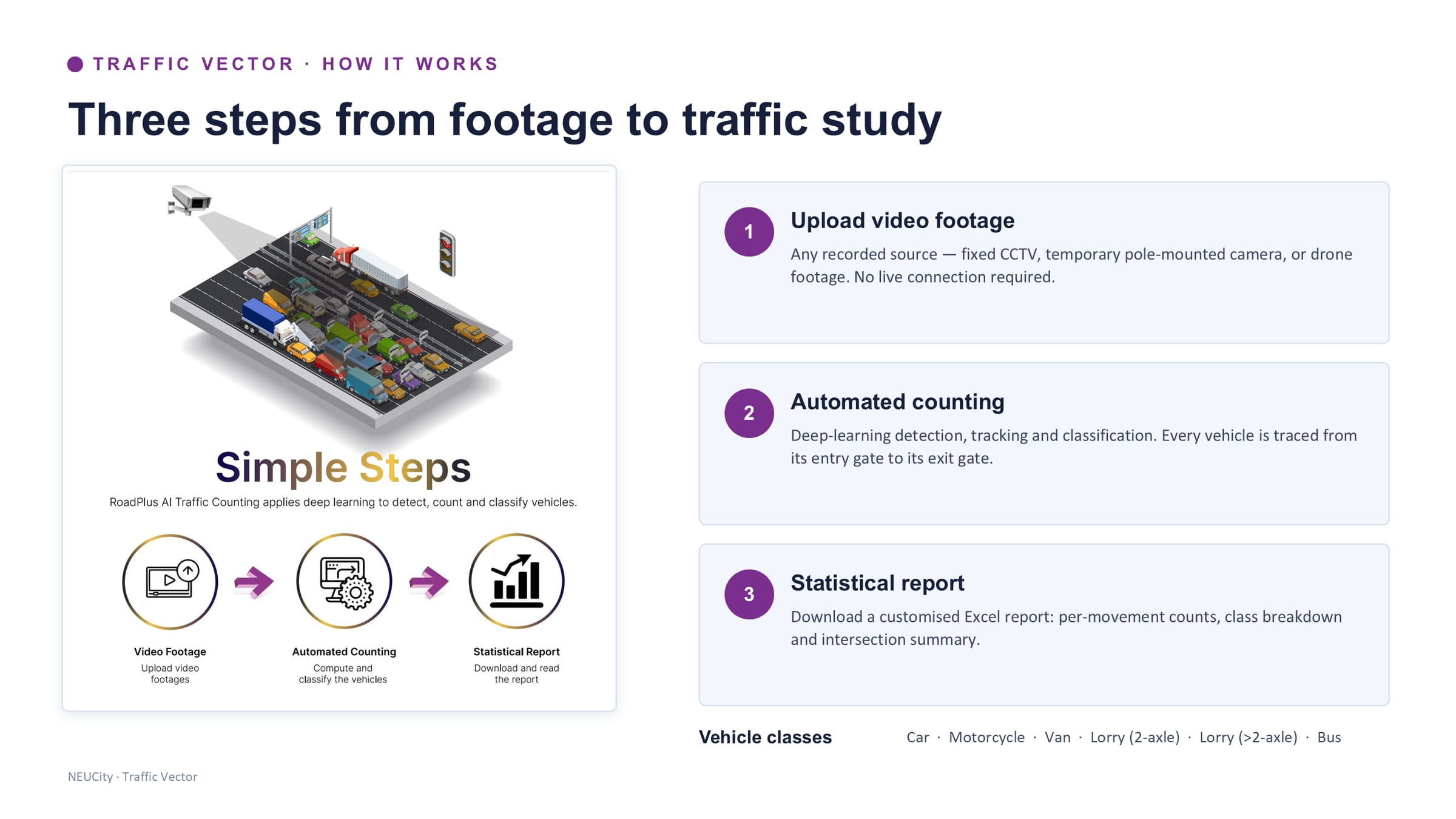
A traffic study is normally people with clipboards or tally counters standing at a junction for hours. Traffic Vector takes recorded footage from any source — fixed CCTV, a temporary pole-mounted camera, or drone video — and produces the same study automatically. No live connection is required, which is what makes it usable at a junction with no additional camera infrastructure.
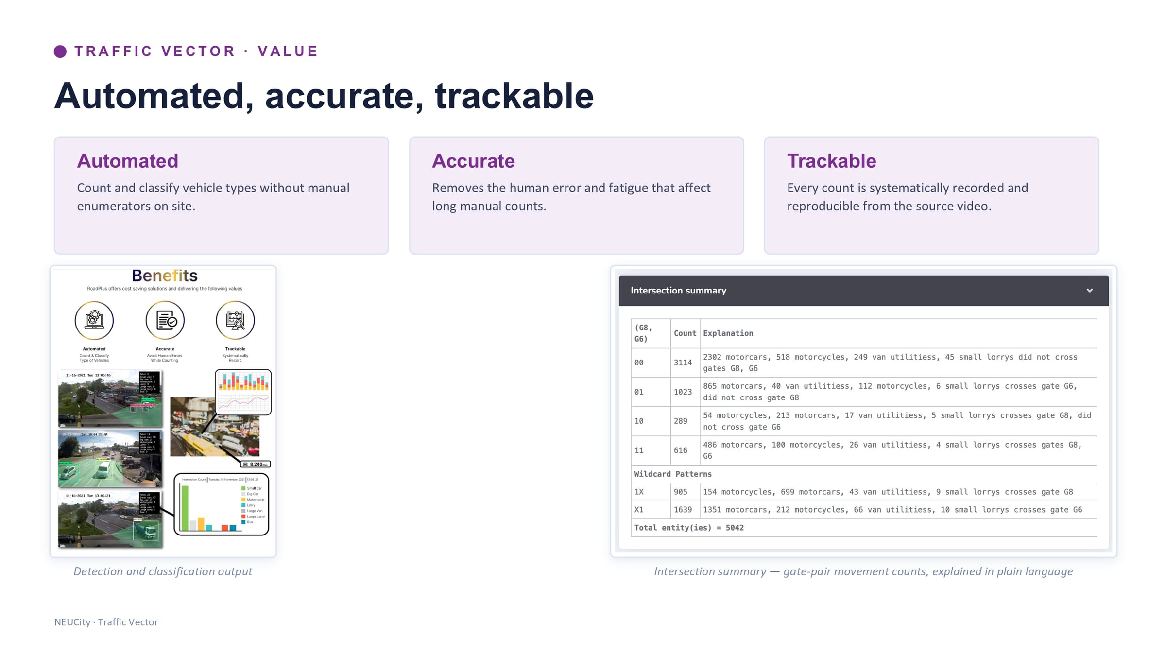
Deep-learning detection, tracking and classification follow every vehicle from its entry gate to its exit gate, across six classes: car, motorcycle, van, 2-axle lorry, over-2-axle lorry and bus. The output is a customised Excel or CSV study — per-movement counts, class breakdown, and an intersection summary that explains each gate pair in plain language rather than leaving a matrix to be interpreted.
The case for it is three words the deck uses: automated, so no enumerators on site; accurate, because it removes the human error and fatigue that affect long manual counts; and trackable, because every count is recorded and reproducible from the source video. That last one is the one planners and consultants care about — a manual count cannot be re-run, and a disputed number cannot be checked.
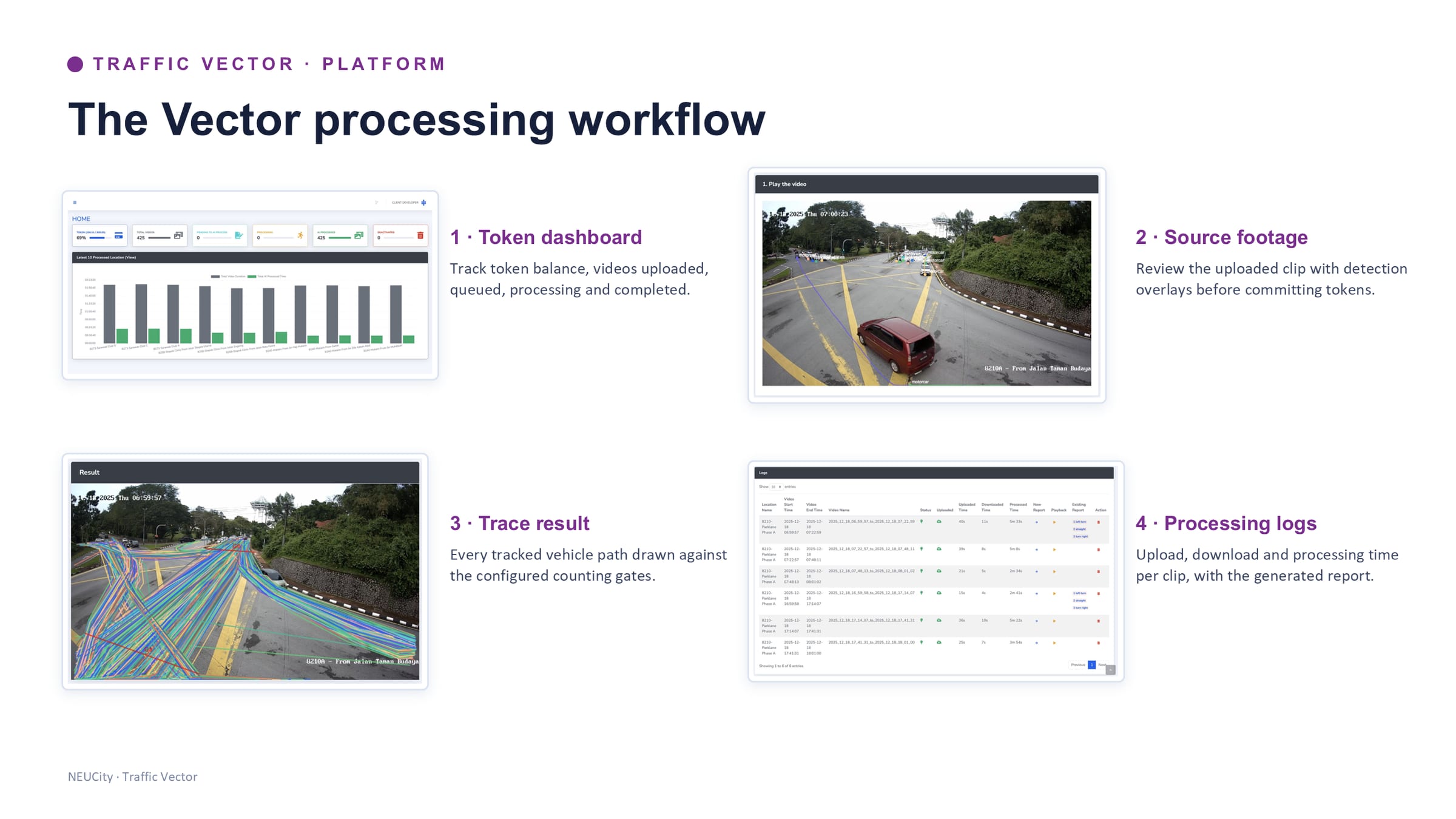
Human quality assurance is available on top of the AI processing, and for organisations that would rather run it themselves there is a self-service platform: a token dashboard, the source footage with detection overlays to review before committing tokens, the traced result drawn against the configured counting gates, and processing logs per clip.
Source 1
Where this came from
- Dr KC's NEUCity deck — “Integrated Traffic Intelligence Suite, Product & Service Catalogue, Version 1.0”, NEUON AI Smart Mobility Division, 34 slides, slide 14 — how it works — three steps from footage to traffic study /assets/img/mobility/slide-14.jpg
Control
Greenlight — control
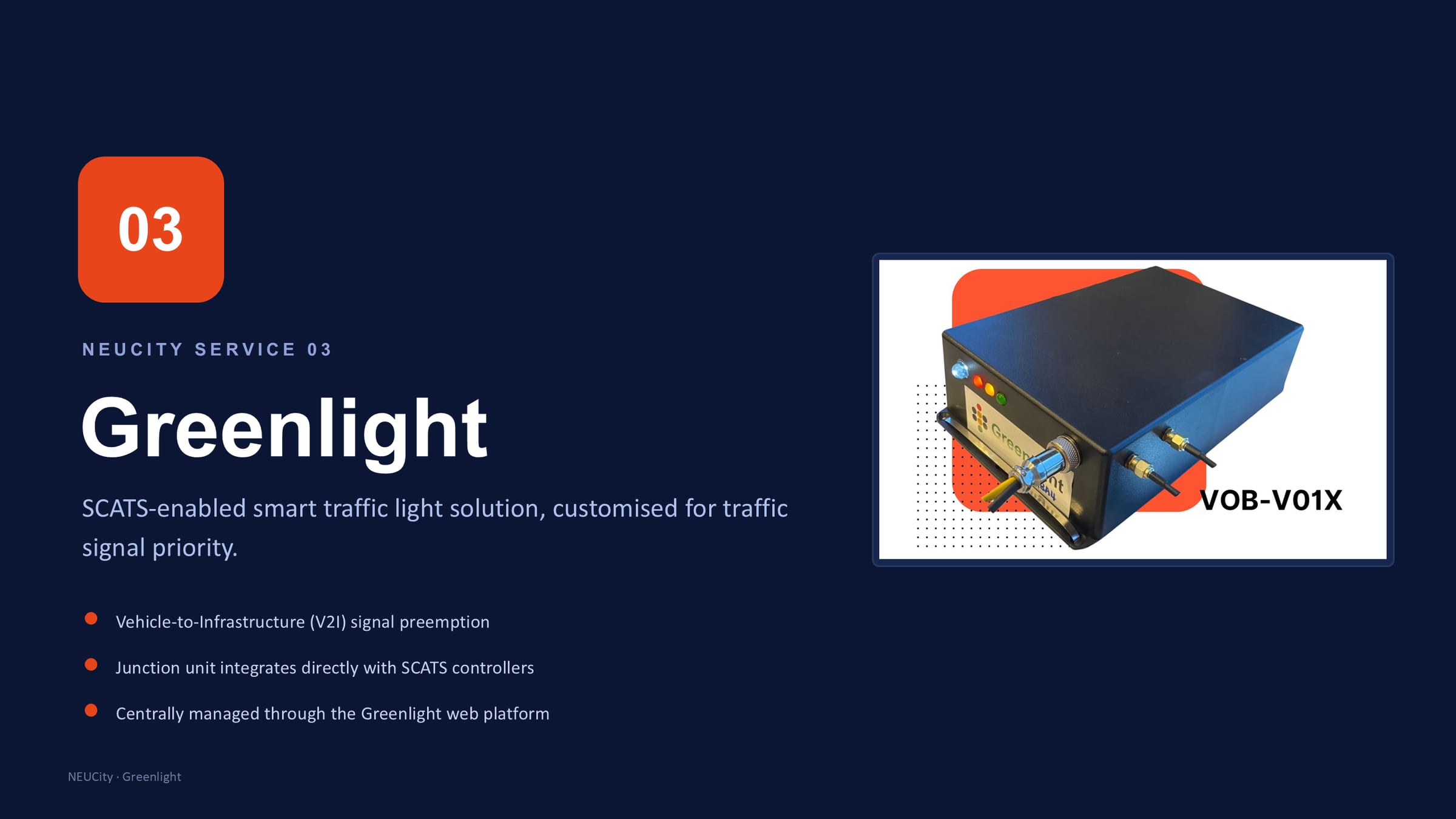
SCATS-enabled vehicle-to-infrastructure signal preemption, for emergency and priority vehicles.
On-board unit in vehicle → V2I junction unit → SCATS controller → signal priority.→ Green-wave preemption
In words
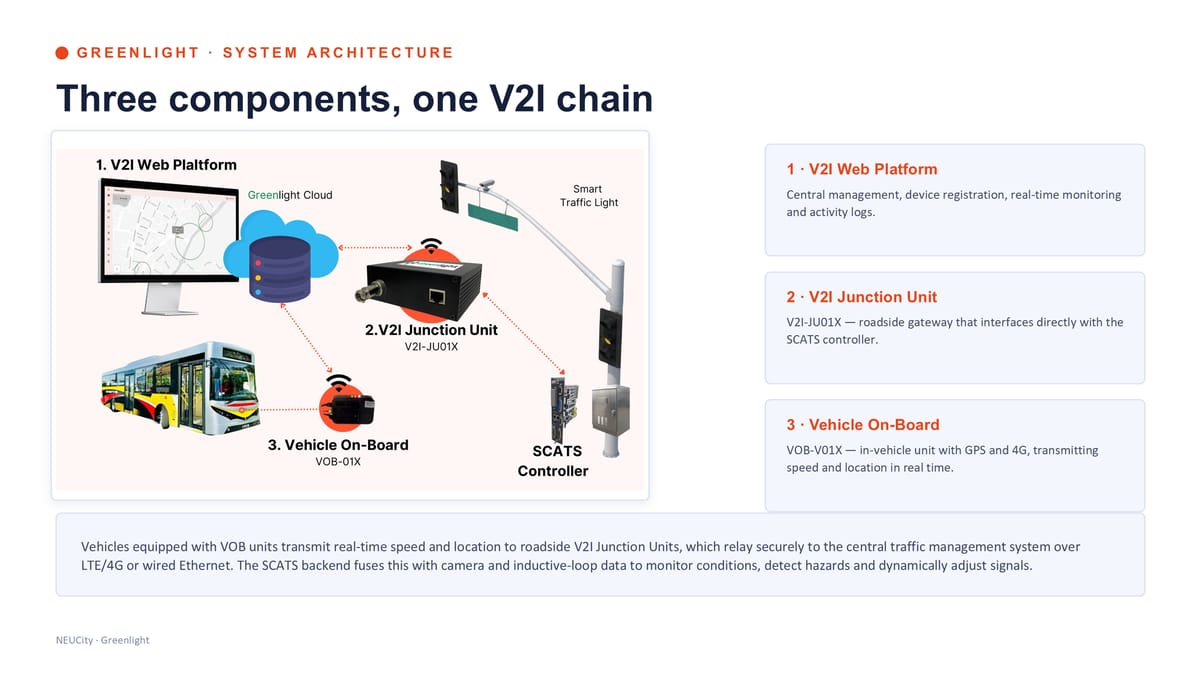
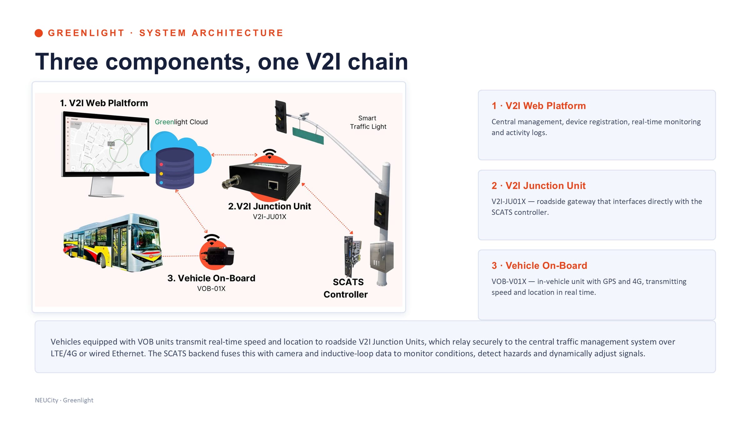
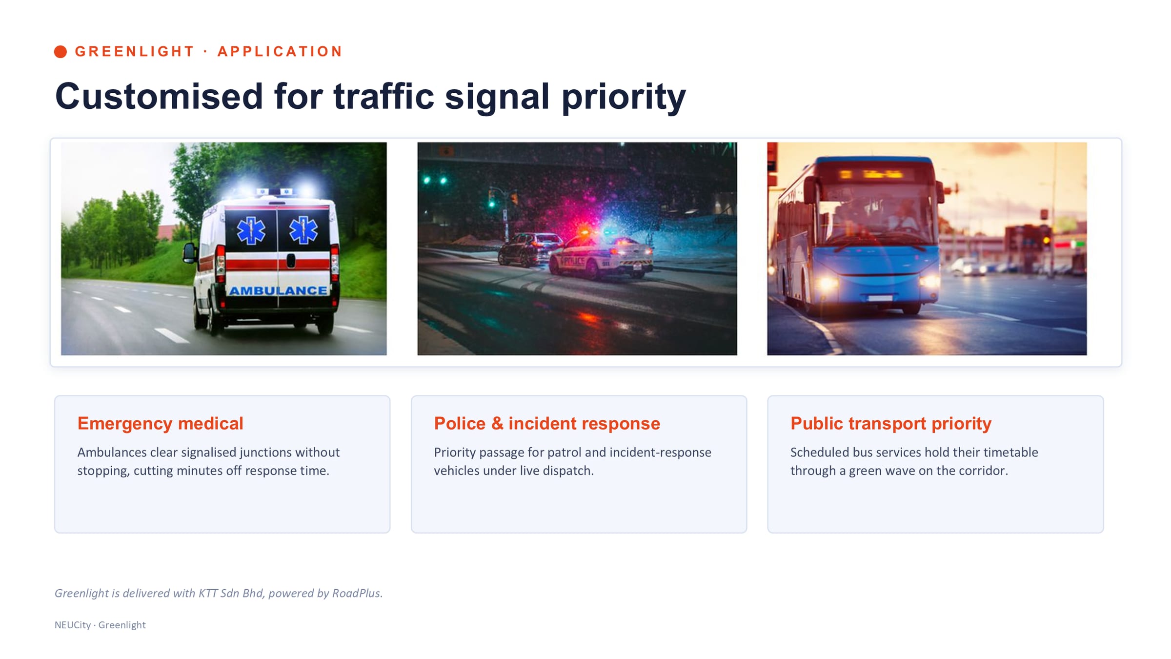
Greenlight is the part of the suite that changes something in the road rather than reporting on it. An in-vehicle unit transmits speed and location in real time; a roadside junction unit receives it and interfaces directly with the SCATS traffic controller; a web platform registers the devices, monitors them and holds the activity log. Together they are one V2I chain, and what comes out of it is a green wave for a vehicle that should not be waiting.
The link from vehicle to roadside runs over LTE/4G or wired Ethernet. The SCATS backend then fuses that with camera and inductive-loop data to monitor conditions, detect hazards and adjust signals dynamically — so preemption is one behaviour of a signal system that is being managed, not a bolt-on that overrides it.
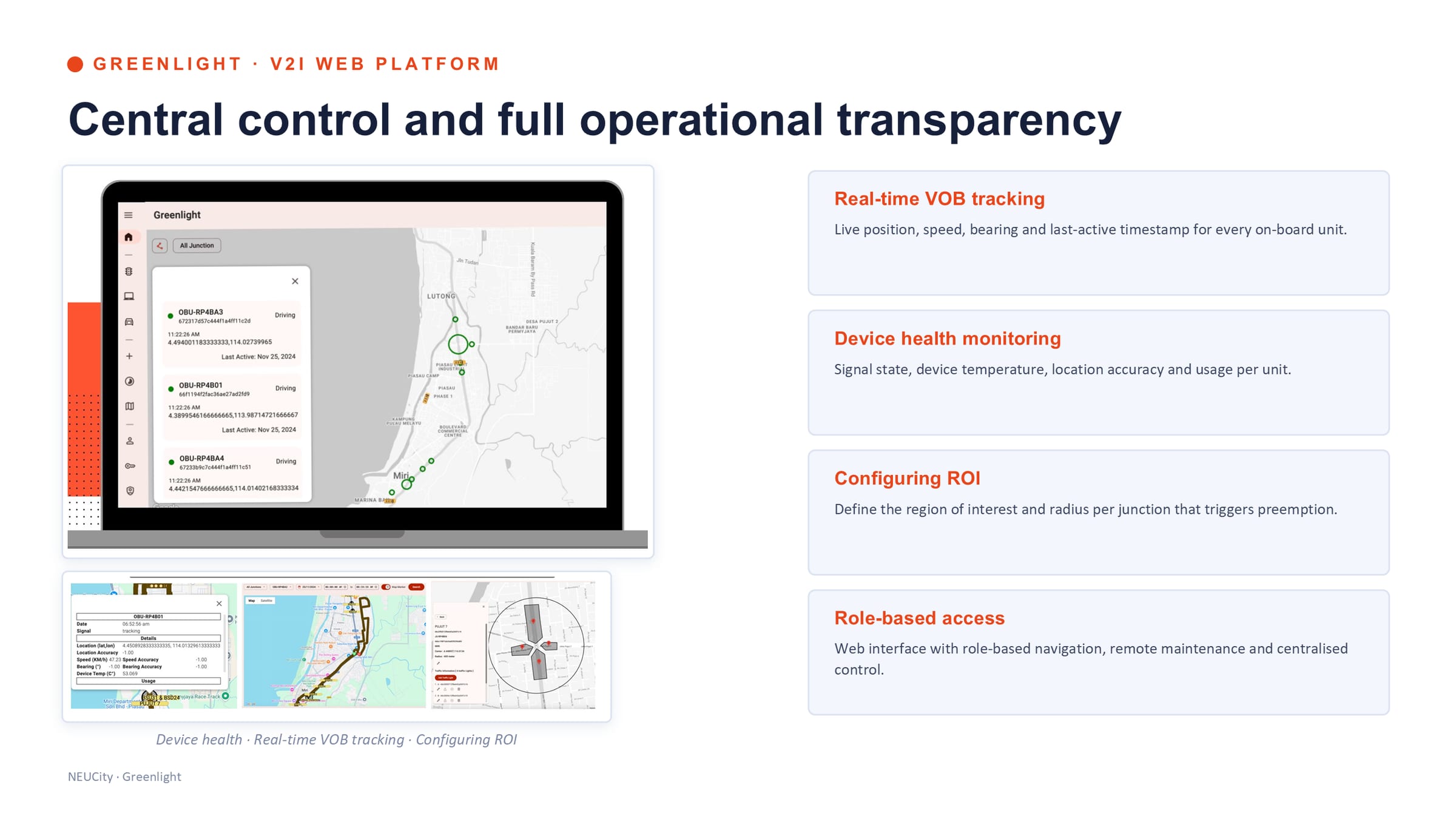
On the platform side: real-time tracking of every on-board unit with position, speed, bearing and last-active timestamp; device health including signal state, temperature, location accuracy and usage; region-of-interest configuration, which is where the radius per junction that triggers preemption is set; and role-based access for remote maintenance and centralised control.
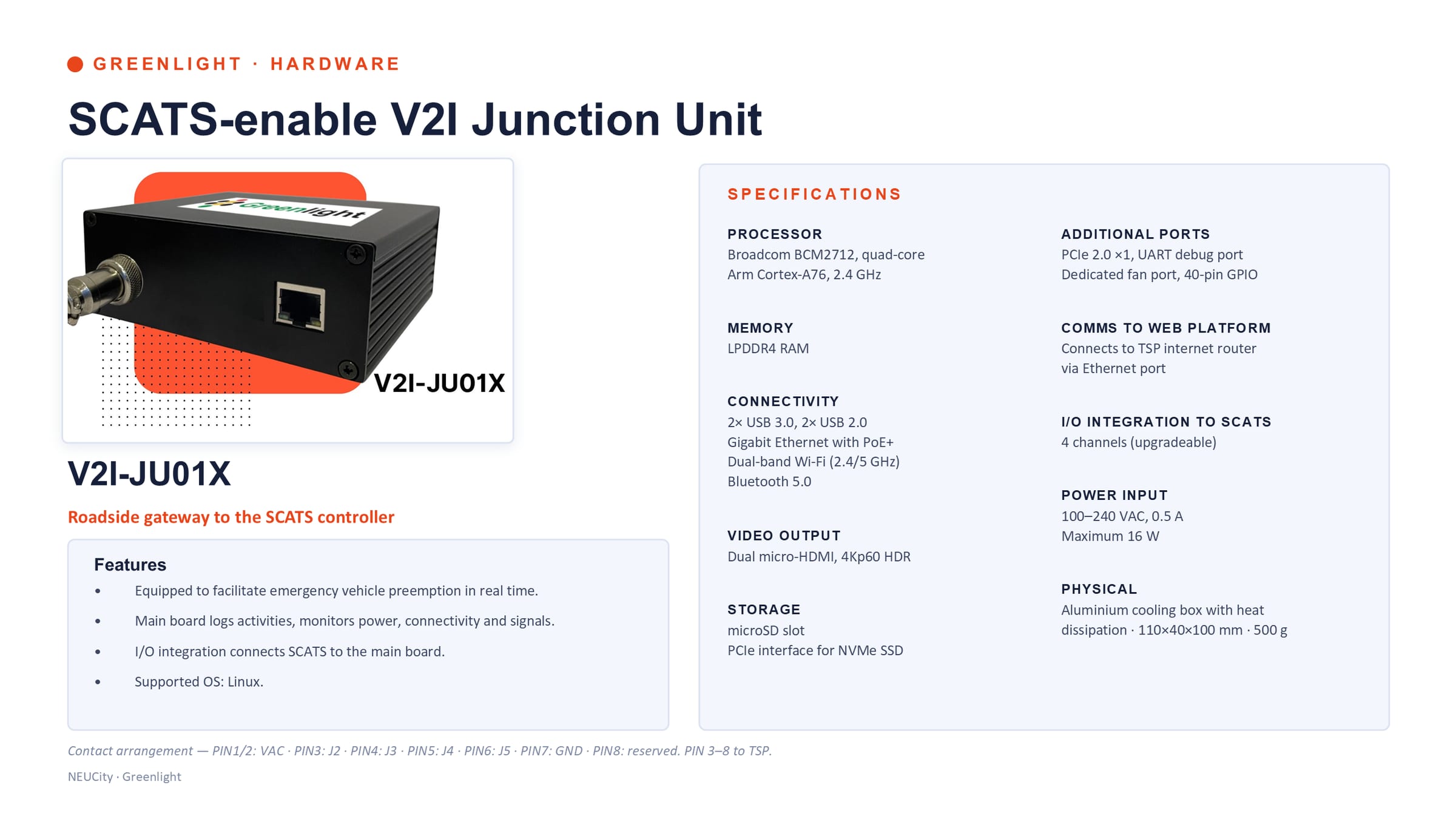
- V2I-JU01X — roadside gateway. Quad-core Arm Cortex-A76 at 2.4 GHz, gigabit Ethernet with PoE+, dual-band Wi-Fi, Bluetooth 5.0, four upgradeable I/O channels to SCATS, 100–240 VAC at 16 W maximum, in an aluminium cooling box of 110×40×100 mm and 500 g. Linux.
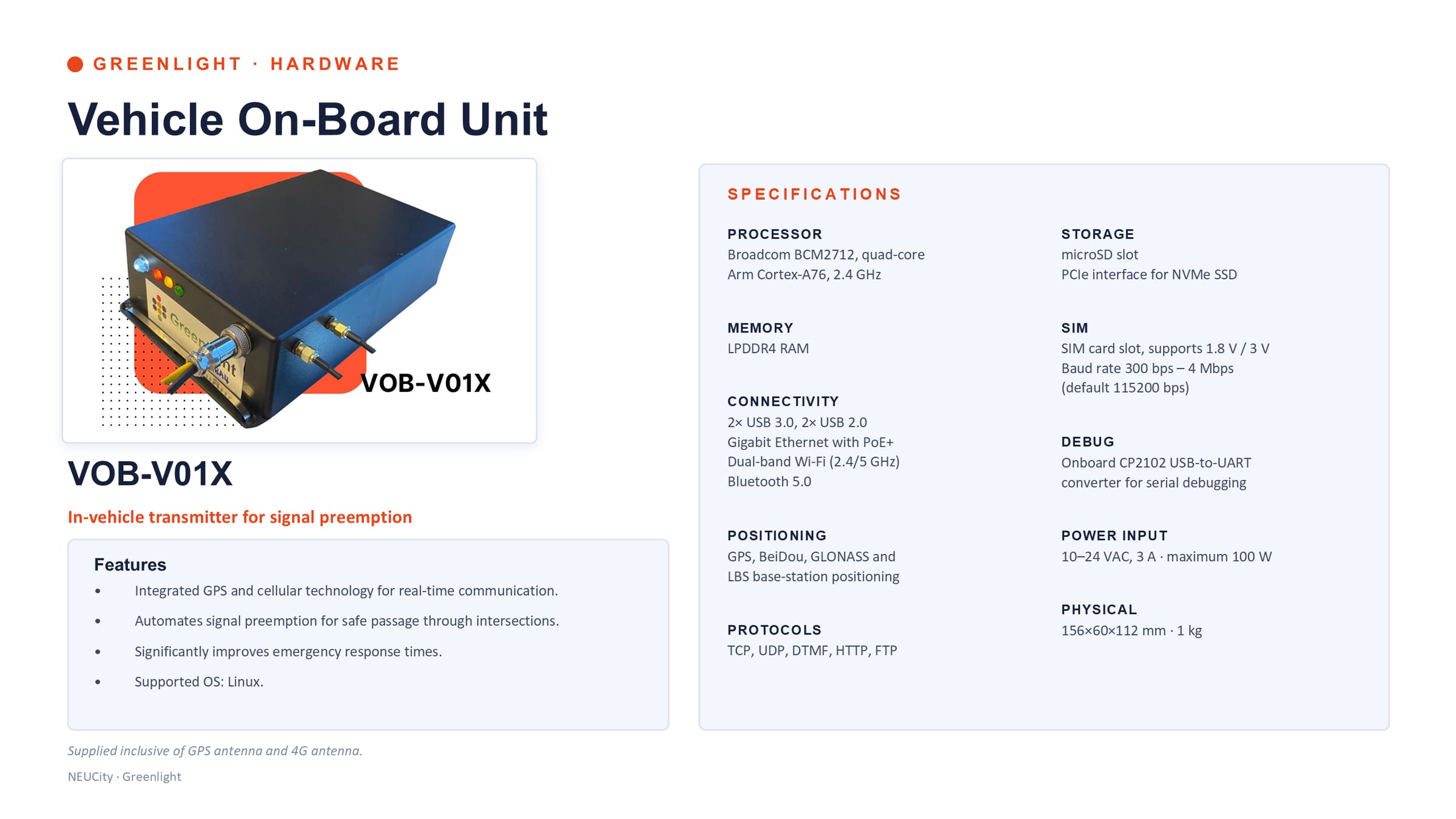
- VOB-V01X — in-vehicle unit. The same compute base with GPS, BeiDou, GLONASS and base-station positioning, a SIM slot, TCP/UDP/HTTP/FTP, 10–24 VAC at 100 W maximum, 156×60×112 mm and 1 kg, supplied with GPS and 4G antennas. Linux.
- Logged, not just done. The junction unit logs main-board activity and monitors power, connectivity and signals — a preemption that happened is a preemption that can be shown to have happened.
Source 1
Where this came from
- Dr KC's NEUCity deck — “Integrated Traffic Intelligence Suite, Product & Service Catalogue, Version 1.0”, NEUON AI Smart Mobility Division, 34 slides, slide 20 — system architecture — three components, one V2I chain /assets/img/mobility/slide-20.jpg
Enforce
D'Reporter — enforce
Illegal-event detection at the edge, with the plate, the clip and the record. On-premise by design.
AI edge device → illegal-event detection → plate extraction → tagged evidence.→ Enforcement record


In words
D'Reporter — documented in engineering as ODEWS, the Obstacle Detection Early Warning System — watches for illegal manoeuvres such as a prohibited U-turn, in real time, on an AI edge device at the junction. When one occurs the device extracts the vehicle's licence plate, pulls the matching footage from the recorder, tags the video, and stores the plate number and the clip as an enforcement record.
It has four layers and they are on-premise by design. Cameras stream continuously to local recorders, which relay to both the central recording server and the AI-Edge device. The edge device runs detection locally in designated regions and pushes events to the central APIs. A central server holds the database, the event clips and the storage pools. A management interface serves admin users, and the application dispatches alerts to the Alert Response Team.
Edge inference is the decision that makes the rest affordable: it avoids the latency, bandwidth and cost of shipping every frame to a central server, because only event metadata and a 15-second clip travel upstream. It is also why the whole system can sit inside one organisation's own network — which for enforcement evidence is not a preference but a requirement.
- Detection and post-processing — real-time illegal-event detection, plate extraction, and footage retrieved from the recorder and tagged to the event.
- Platform and delivery — a web dashboard of all detected events and records, a backend database for event data and evidence clips, and a web interface for warning-log review and technical reporting.
- Licence-plate recognition integrated with post-processing, specifically to keep the computing cost on the edge device down.
- Hardware and configuration — the AI-embedded device with the NEUON core is rented monthly; setup covers core training and deployment on the device, cloud framework for syncing, and VLAN for remote maintenance.
Source 1
Where this came from
- Dr KC's NEUCity deck — “Integrated Traffic Intelligence Suite, Product & Service Catalogue, Version 1.0”, NEUON AI Smart Mobility Division, 34 slides, slides 25–30 — withdrawn from this site on 22 August 2026 at the CEO’s instruction. The deck is the record; the slides are not published.
Architecture of the suite
From passive infrastructure to actionable control
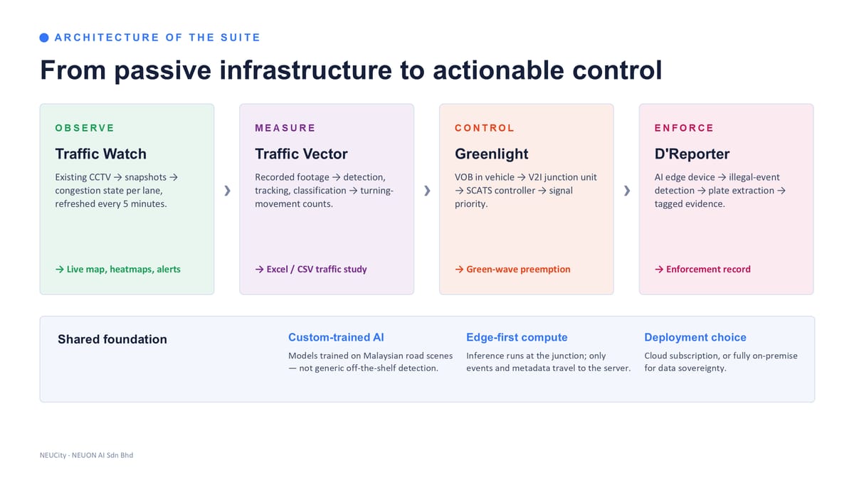
-
Observe
Traffic Watch
Existing CCTV → snapshots → congestion state per lane, refreshed every 5 minutes.
→ Live map, heatmaps, alerts
-
Measure
Traffic Vector
Recorded footage → detection, tracking, classification → turning-movement counts.
→ Excel / CSV traffic study
-
Control
Greenlight
On-board unit in vehicle → V2I junction unit → SCATS controller → signal priority.
→ Green-wave preemption
-
Enforce
D'Reporter
AI edge device → illegal-event detection → plate extraction → tagged evidence.
→ Enforcement record
Shared foundation
Custom-trained AI
Models trained on Malaysian road scenes — our junctions, our vehicle mix, our weather — not generic off-the-shelf detection. It is why the accuracy holds up at night and in heavy glare.
Edge-first compute
Inference runs at the junction; only events and metadata travel to the server. That is what keeps bandwidth, storage and latency low enough to be affordable at network scale.
Deployment choice
A cloud subscription, or fully on-premise for data sovereignty. The same suite either way.
Source 1
Where this came from
- Dr KC's NEUCity deck — “Integrated Traffic Intelligence Suite, Product & Service Catalogue, Version 1.0”, NEUON AI Smart Mobility Division, 34 slides, slide 03 — architecture — from passive infrastructure to actionable control /assets/img/mobility/slide-03.jpg
A cloud subscription or fully on-premise — see Sovereign Applied AI for what that commitment means.
On the road
Not a proposal. Serving Sarawak since 2021.
- RoadPlus. The flagship — AI-powered community road inspection with JKR Sarawak, CMS Roads and MPP Padawan. Winner of the World Summit Award 2025 and the Sarawak Premier's Award. roadplus.my
- Standards and partners. Standards recognised by JKR Sarawak. Greenlight delivered with KTT Sdn Bhd, powered by RoadPlus.
Engagement
How a deployment runs
- Scope. Confirm junctions, cameras, target resolution, and which of the four services apply.
- Pilot. A short pilot on a small camera set — accuracy and value proven on your own roads before scale.
- Deploy. Commissioning with your camera and recorder vendor, network provisioning, platform onboarding.
- Operate. Monthly subscription or study-by-study engagement, with reporting and support in place.
What we need from you
- Camera or recorder access with streaming enabled, coordinated with your camera vendor.
- A confirmed junction list, and for D'Reporter a target video resolution.
- Central site connectivity for on-premise deployments.
- A nominated operational owner for alerts and reporting.
The lowest-risk way in is Traffic Watch on a handful of cameras already in the ground: no site works, no new sensors, a live congestion map within days. Scopes, intervals, camera counts and commercial terms are quoted per deployment — write to us and we will put numbers against your junction list.